
Watercourse Mapping in the Gallatin Valley
The Lower Gallatin Watershed is woven with natural streams and man-made ditches. This network of watercourses is very dynamic and interconnected, both hydrologically and culturally. As our community and the climate changes, it becomes increasingly important to manage the many miles of this distribution system collectively. Unfortunately, much of the existing irrigation infrastructure is antiquated, and watercourse maps are outdated, inaccurate, and incomplete. The first step towards sustainable water distribution for a healthy and productive landscape is to know where and what watercourses are, so that the many stakeholders involved can better understand how they are connected, what regulations apply, and which best management practices are appropriate.
Watercourse Mapping Dashboard
3D Hydrography Program (3DHP) is a national program managed by the USGS to acquire high-resolution elevation data using LiDAR. These new maps will improve data accuracy and provide more current data than is available in the National Hydrography Dataset, which has been the primary source of stream and ditch maps for more than 20 years.
In 2024, the Gallatin Water Collaborative formed the Watercourse Mapping Working Group to apply to the USGS 3D Hydrography Program and raise matching funds. By the end of 2025, the group secured $111,000 and submitted an application to map the entire Gallatin Watershed. This January, the group learned the application was successful, securing an additional $130,000 cost-share from the USGS. Mapping will begin in the spring of 2026.
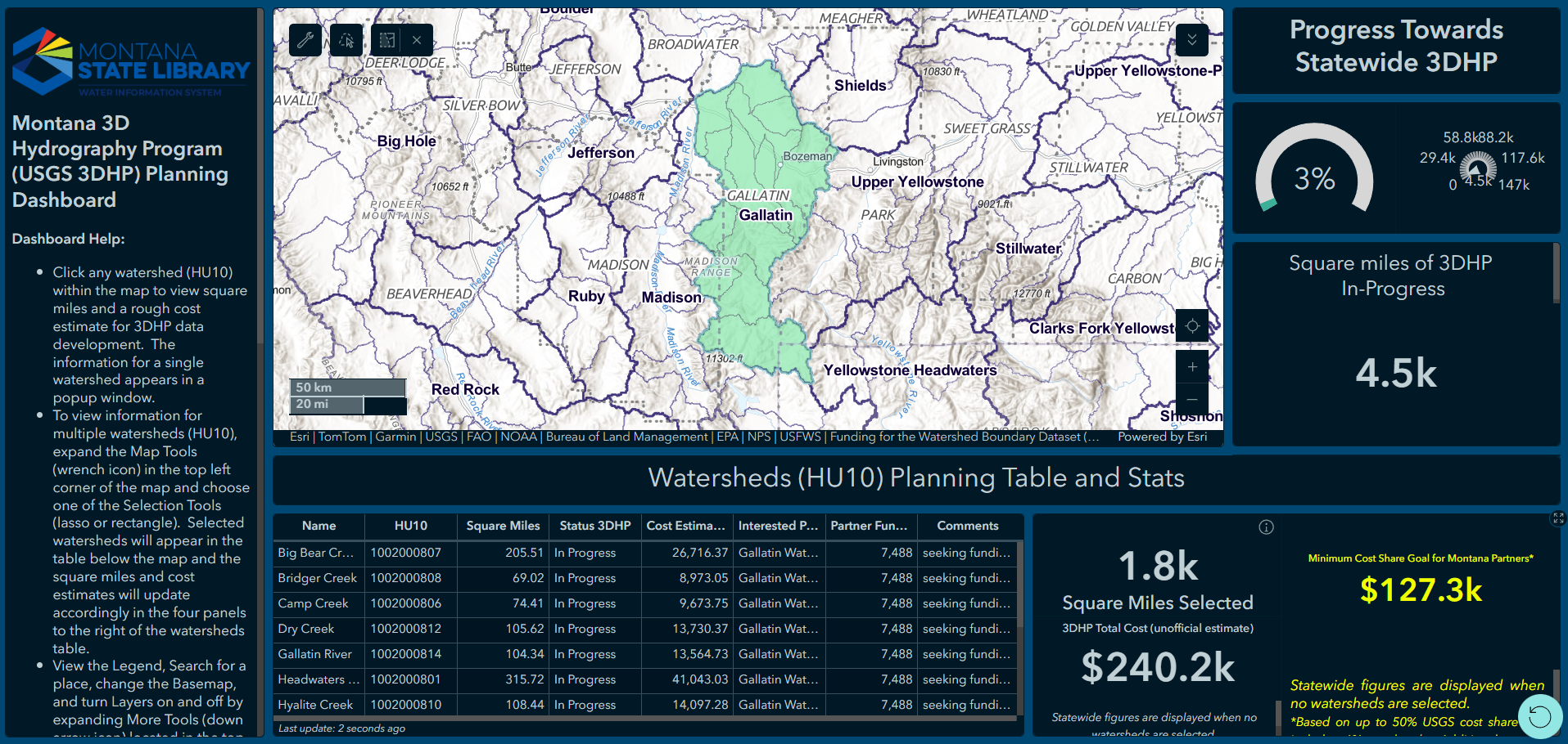
Click on the image to view the Montana 3D Hydrography
Program Planning Dashboard.
Thanks to the following partners for helping to financially support the Watercourse Mapping project: USGS, Gallatin Conservation District, Montana Department of Environmental Quality, Custer Gallatin National Forest, Montana State Library, Gallatin County, the Association of Gallatin Agricultural Irrigators, and the Gallatin Watershed Council. If your group is interested in supporting this work, contact Lilly McLane at lilly@gallatinwatershedcouncil.org


Resources
3D Hydrography Program National States Geographic Information Council Information Hub
3D Hydrography Program Benefits and Applications
3D Hydrography Program Montana Planning Map
Elevation-Derived Hydrography READ Rules
Elevation-Derived Hydrography Data Acquisition Specifications
3D Hydrography Program FAQs: Funding